
Early settlement to 1972
Early Beginnings
By Noel C. Ayoc
A source-led account of Mahaplag as an upland frontier, its settlement patterns, waterways, migration, roads, and political formation.
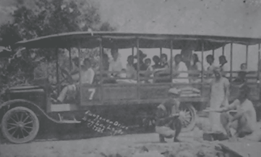
During the Spanish and American colonial periods, historical records frequently mentioned established towns such as Sogod, Abuyog, and Baybay, while the area now known as Mahaplag remained largely unrecorded in formal colonial documentation. This archival silence does not necessarily indicate historical absence; rather, it reflects Mahaplag’s position as a transitional upland frontier zone situated between major coastal and inland settlements.¹
From a spatial-historical perspective, Mahaplag functioned as a corridor landscape characterized by gently rolling uplands, forested interiors, and dispersed river systems. Such environments in the Visayas were often not heavily documented by colonial administrators unless they were economically or strategically mobilized.² Nevertheless, these uplands likely served dual functions: as agricultural frontiers for early swidden farming and as refuge zones during periods of colonial disruption and armed resistance.
Geographically, Mahaplag occupies a strategic interior position in Leyte Island, linking western and southern corridors to the eastern seaboard, including Tacloban, the provincial capital. This connectivity later shaped patterns of migration, settlement expansion, and resource extraction.
The absence of Mahaplag in early colonial records should be interpreted within the broader historiography of Philippine upland societies, where interior landscapes were frequently marginalized. William Henry Scott emphasizes that precolonial Visayan societies were characterized by mixed subsistence systems combining rice agriculture, root crops, and forest-based resources, allowing for flexible settlement patterns across ecological zones.³
Within this interpretive framework, Mahaplag emerges as part of a non-centralized upland habitation system, where settlements were necessarily fragile and adaptive—dispersed along rivers, hidden in forested landscapes, structured by kinship, and lightly built to withstand the uncertainties of the period.
Origins of Settlement
Mahaplag’s early history is closely tied to Abuyog, its mother municipality. In the early Spanish colonial period, Abuyog in Leyte was entrusted as an encomienda first to Don Gaspar de los Reyes and later to Don Francisco Albarez, whose oppressive tribute collections stirred deep resentment among the natives.⁴ In 1588, the people rose in revolt and fatally attacked the encomendero.⁵ This incident exposed the dangers of encomienda abuses, hardened Spanish attitudes, instilled mistrust among the natives, and delayed Abuyog’s full incorporation into the missionary network. This provides an important historical backdrop for understanding patterns of movement and settlement, suggesting that contemporaneous shifts into the interior—areas that would later form part of Mahaplag—may already have been underway.
Initial settlements likely emerged as swidden (kaingin) farms established by migrants from Abuyog and nearby communities. Scott notes that Visayan subsistence patterns in the sixteenth century centered on mixed agriculture, combining rice cultivation with root crops such as taro and yams.⁶ Given the difficulty of sustaining year-round rice production, early settlers depended on diversified food sources, shaping both land use and settlement patterns.
This pattern of upland occupation persisted into the twentieth century, as demonstrated in the case studies of Dargantes and Koch on forest land use in Leyte.⁷ They observed that kaingin practices contributed significantly to the occupation and cultivation of logged-over areas. Former concession lands, such as those of the Velbros Timber Corporation, were gradually converted into agricultural spaces following the cessation of operations in 1973. Residents in adjacent communities began planting coconut and cultivating these areas, although some parcels were later sold to entrepreneurs from Mahaplag, Abuyog, and Javier who expanded coconut production.
Furthermore, their study highlights the barangays of Hinaguimitan and Uguis, which later formed part of the Mahaplag Settlement Project—the precursor to the Leyte Settlement Project (LSP). Established through Proclamation No. 418, approved on July 1, 1994, the program aimed to resettle landless farmers, qualified farming families, and rebel returnees.
This pattern of dispersal and land transformation reflects a broader Philippine colonial and postcolonial trend in which upland environments functioned as refuge zones during periods of resistance, economic transition, and ecological change. From these movements, early settlement forms in Mahaplag gradually took shape.
Indigenous Mobility and the Mamanuan Comparative Lens
A useful interpretive framework for understanding Mahaplag’s upland landscape can be drawn from studies on Indigenous mobility in Eastern Visayas and Mindanao. Kahambing describes Indigenous groups as historically itinerant, with movements shaped by forest ecology, resource availability, and socio-political displacement.⁸ The Mamanuan identity is linguistically associated with man (first) and banwa (forest or settlement), referring to early forest dwellers. This framing highlights their association with upland ecosystems and resource-based mobility.
Kahambing further conceptualizes diaspora as a “vanishing mediator,” useful for understanding upland ecologies such as Mahaplag, where mobility is not merely displacement but a mode of inhabiting forest landscapes shaped by resources such as rattan (uway) and medicinal plants.
The presence of ka-olisihan (rattan-rich zones) in Mahaplag’s forest interiors, such as Palanogan, aligns with this resource economy.⁹ Even without direct historical evidence of a permanent Mamanuan settlement in Mahaplag, ecological parallels suggest that the area functioned as part of a broader Visayan upland mobility corridor.
Riverine Landscapes
Early settlement in Mahaplag was strongly oriented toward rivers, creeks, and tributaries like Mahaplag, Campin, Hilusig, Pinamonoan, Polahongon, and Hiluctogan.¹⁰ These waterways functioned as connective arteries facilitating transport, trade, and cultural exchange. The Layog River, in particular, played a crucial role in mobility and later in timber transport during the logging era. The term “Layog District,” used prior to municipal establishment, reflects its historical centrality. Nick Joaquin notes that Philippine society has long been shaped by water-based lifeways influencing settlement and cultural patterns.¹¹
Kinship and Community Formation
There is no single documented account identifying the first settlers of Mahaplag. Consistent with decentralized barangay systems, settlement formation occurred through kinship-based migration networks.¹² Dargantes and Koch argue that strong family ties are manifested in clustering of households and shared production systems, reinforcing usufruct rights over forest lands transmitted through inheritance.¹³
Oral histories from Palanogan show that families such as Montiman and Escasinas trace their origins to Pomponan, Baybay, while the Alajas lineage traces to Caridad, Baybay.¹⁴
Migration extended beyond Leyte. Southern Cebu—particularly Argao and Dalaguete—and Loon, Bohol facilitated maritime movement across the Camotes Sea. Migrants typically passed through coastal towns such as Baybay, Hindang, Inopacan, Hilongos, Bato, and Matalom before moving inland to Mahaplag. Migrants from Loon initially engaged in itinerant trade before permanent settlement.¹⁵ By the 1970s, Muslim traders had also become active in the poblacion market, with some later putting down permanent roots in the community.¹⁶ One notable example was Hadji Sariff Raconday, a native of Taraka, Lanao del Sur, who married Josefina Borja of Tahud, Inopacan. He began a trading business in Mahaplag and later encouraged family members and relatives to join him in the area.
Road Development, Timber Extraction and Settlement Expansion
The development of Mahaplag as a distinct settlement—and later as a municipality—must be understood in relation to the construction of the trans-island road linking Abuyog on the eastern coast and Baybay on the western coast of Leyte. Conceived as early as 1903 during the American Insular Government, this infrastructure project formed part of a broader colonial agenda aimed at strengthening administrative control and promoting economic integration across the island. In an official report submitted to the Philippine Commission that same year, Seely B. Patterson proposed the construction of a trans-island wagon road, identifying the absence of a reliable east–west route across Leyte’s central mountain range as a major impediment to mobility, governance, and trade.¹⁷
The proposed route, measuring approximately 45 kilometers, traversed rugged and largely inaccessible terrain that, at the time, was connected only by narrow mountain trails. Patterson recommended a budget of $30,000 for what he described as a first-class wagon road engineered with proper grading and drainage, and surfaced with macadam or compacted gravel to support the movement of heavy carts and freight wagons. Although conceived in the early American period, the road was only completed in 1936 and formally inaugurated by Sergio Osmeña, then Vice President of the Commonwealth under Manuel L. Quezon.
The opening of this trans-island corridor marked a turning point in the spatial and economic development of this inland area of Leyte. Settlements expanded along this corridor such as Hilusig, Cuatro de Agosto, and Liberacion. By facilitating easier movement of people, goods, and government services, the road stimulated migration into previously remote upland areas, including what would later become Mahaplag. Settlements along the route gradually expanded as agricultural opportunities increased and access to coastal markets improved. Over time, these growing communities developed a degree of economic viability and administrative coherence that supported their eventual political separation from Abuyog. Thus, the establishment of Mahaplag as a municipality in 1958 can be seen not as an isolated administrative act, but as the culmination of decades of infrastructural development and settlement consolidation initiated by the construction of the Abuyog–Baybay trans-island road.
During the first half of the twentieth century, Mahaplag’s forests were integrated into regional logging networks. Concessions were granted to Veloso enterprises, Highland Sawmill, Maco Stevedoring Corporation (Mastecor), and Timber Producers and Marketing Corporation (TMPC).¹⁸
Infrastructure development accelerated extraction. The Baybay–Abuyog Road, inaugurated in 1936 by Sergio Osmeña Sr., connected eastern and western Leyte, facilitating movement of timber and labor.¹⁹
The 1950s saw intensified logging along the Layog River, with concessionaires establishing sawmills under Bureau of Forestry permits. Worker settlements known as pong-on emerged, and cleared forest lands were converted into abaca and coconut farms.²⁰ Land suitability perceptions encouraged occupation of logged-over areas, as noted by Dargantes and Koch.²¹ This led to the emergence of settlements such as Brgy. Hinaguimitan.
Road networks such as Poblacion–San Isidro, Malinao–San Juan, and Hilusig–Magsuganao were built to support logging operations. In 1962, Highland Sawmill began operations in San Juan, later succeeded by Mastecor.²²
The latter half of the twentieth century marked a transition from river-based to road-based transport. The Mahaplag–Sogod Road, surveyed in 1962 and opened in 1972, improved regional connectivity.²³
The 48.22 km Mahaplag–Hilongos Road infrastructure project, which starts at Brgy. San Isidro in Mahaplag and passes through the municipalities of Inopacan and Hindang before reaching Brgy. San Roque in Hilongos, Leyte, is expected to significantly reduce travel time between Tacloban City and Maasin City in Southern Leyte in the near future.²⁴
Mahaplag as a Political Unit
Mahaplag became an independent municipality on July 21, 1958, through Executive Order No. 308 issued by President Carlos P. Garcia, with the support of Speaker Daniel Z. Romualdez.²⁵ The Order designated Barrio Mahaplag as the seat of government and delineated seventeen additional barrios to constitute the newly established municipality, namely: Hilusig, Cuatro de Agosto, Liberacion, Himamara, Tagaytay, Hinaguimitan, Upper Mahaplag, Palanogan, Campin, Mabunga, Mahayag, Malinao, Union, Uguis, Mahayahay, Polahongon, and Pinamonoan.²⁶ Thus, Magsuganao, Paril, Malipoon, Sta. Cruz, San Isidro, San Juan, Maligaya, Mabuhay, Hiluctugan, and Sto. Niño are relatively newer barangays.
The municipality was inaugurated on October 11, 1958, with Angel I. Gubat appointed as its first mayor (1958–1960) and Cayetano P. Bartolini as vice mayor. In the November 1960 elections, Felicisimo T. Abuyabor became the first elected mayor, with Ishmael Lleve serving as vice mayor. Republic Act No. 6529 later declared Mahaplag, on July 22, 1972, as a duly constituted municipality in the Province of Leyte, with the seat of government in Barangays Malinao and San Isidro.²⁷
Notes and sources
-
William Henry Scott, Barangay: Sixteenth-Century Philippine Culture and Society (Quezon City: Ateneo de Manila University Press, 2017), 12–15.
-
Scott, Barangay, 45–47.
-
Scott, Barangay, 63–66.
-
Ryan Claridad Japon, Facebook post, October 19, 2025, Facebook, “Parroquia de San Francisco Javier.”
-
Rolando H. Imperial, Leyte (1898–1902): Ang Digmaang Pilipino–Amerikano (Manila: Information, Publication and Public Affairs Office, University of the Philippines Manila, 2014), 22–24.
-
Scott, Barangay, 71–73.
-
Buenaventura B. Dargantes and Werner Koch, “Case Studies on the Occupation and Cultivation of Forest Lands in Leyte, Philippines,” Annals of Tropical Research 16, no. 2 (1994): 13–29.
-
Jan Gresil S. Kahambing, “Theorizing Mamanuan Diaspora: From Vanishing Mediator to Performative Indigeneity,” Rupkatha Journal on Interdisciplinary Studies in Humanities 11, no. 2 (2019).
-
Teresita A. Avila, personal communication with the author, March 28, 2021.
-
Job D. Abuyabor, personal communication with the author, September 13, 2020.
-
Nick Joaquin, Culture and History (Pasig City: Anvil Publishing, 2017), 88–91.
-
Scott, Barangay, 102–104.
-
Dargantes and Koch, “Case Studies,” 18–20.
-
Lilia R. Andrade, personal communication with the author, January 15, 2014; Teresita A. Avila, personal communication with the author, March 28, 2021; Conchita A. Pacayde, personal communication with the author, January 18, 2014; Leonisa M. Moreno, personal communication with the author, January 12, 2014.
-
Noel P. Coretico, personal communication with the author, July 16, 2020.
-
Gina Raz Elardo, personal communication with the author, May 6, 2026.
-
Report of the Philippine Commission, 1903 (Washington, D.C.: Government Printing Office, 1904); Official Gazette of the Commonwealth of the Philippines, 1936.
-
Job D. Abuyabor, personal communication with the author, May 4, 2021; Agapito Madis, personal communication with the author, May 11, 2021; Crisanto Damalerio, personal communication with the author, May 11, 2021; Rogelio Panal Abenoja, personal communication with the author, May 31, 2021; Eulogio Mejia, personal communication with the author, June 14, 2021; Porferio Bulak Pabroa, personal communication with the author, May 22, 2021; Emmanuelita B. Gerong, personal communication with the author, January 7, 2023.
-
Report of the Philippine Commission, 1903 (Washington, D.C.: Government Printing Office, 1904); Official Gazette of the Commonwealth of the Philippines, 1936.
-
Job D. Abuyabor, personal communication with the author, May 4, 2021.
-
Dargantes and Koch, “Case Studies,” 22–24.
-
Job D. Abuyabor, personal communication with the author, May 4, 2021; Agapito Madis, personal communication with the author, May 11, 2021; Crisanto Damalerio, personal communication with the author, May 11, 2021; Rogelio Panal Abenoja, personal communication with the author, May 31, 2021.
-
Municipal Government of Mahaplag, Mahaplag Municipal Profile (Mahaplag, Leyte: Municipal Planning and Development Office, 2018), soft copy.
-
Josie Serseña, “Fifth District of Leyte: Dali ug sayon nga pagbiyahe pinaagi sa Mahaplag–Hilongos Road,” Kinto Bandilyo News 1, no. 1 (January–June 2021).
-
Municipal Government of Mahaplag, Mahaplag Municipal Profile.
-
Republic of the Philippines, Executive Order No. 308: Creating the Municipality of Mahaplag in the Province of Leyte (July 21, 1958), Official Gazette.
-
Republic of the Philippines, Republic Act No. 6529: An Act Constituting the Municipality of Mahaplag in the Province of Leyte (July 22, 1972), Official Gazette.